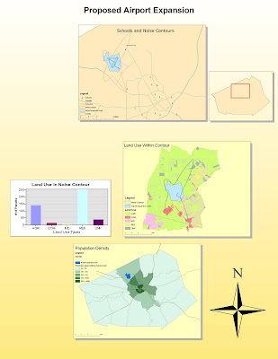
In this project, I took my first major steps into the world of ArcGIS software. Working through the tutorial I was able to experiment with different basic tools within the software and learn how to label maps and objects on them, size different representations accurately relative to each other, and better conceive how different spatial data represent real space and intertwine to create a comprehensive representation of an area. Since I was able to go through the different layers of the map I could learn about different related factors individually and so better come to conclusions about the relationships between these areas (i.e. the schools relating to the tract zones relating to the noise contour). In learning how to place new roadways I was able to dip into the manipulation of existing map data, which was interesting because the program makes it so simple. I was also able to consider how the simplicity of using and manipulating the maps representing the imported spatial data might hinder the potential for true accuracy.
This GIS technology is, I feel, essential to the analysis of space as it exists within modern thought. As space becomes more and more complex, building upon itself to the point where new networks hardly take up any real "space" at all, we increasingly need the capabilities of GIS to help us manage the ever developing and complexifying nature of the spaces in which we live our lives. Thankfully, there is the data out there as people from all disciplines and all walks of life collect increasing amounts of spatial data for both their experiments and to supplement their everyday lives. With GIS, this data is easily manageable and made expressible in many different forms. As we pile streets over sewers, neighborhoods over streets, and both landline and wireless communication networks over these neighborhoods, the layers off distinct but interrelated data also pile up. Since GIS allows for us to take these layers into account and distribute our data specifically to these, we can visually assess the otherwise abstract notions of spatial zoning, boundaries and overlap. Not only that, but GIS lets us link factors between layers, connecting them so that changes made on one side will no go unnoticed by affected elements within another layer.
As helpful as GIS is, we must work with caution and skill. Working with the pure data is tedious and sketchy. Any mismatch can lead to huge problems because of the way GIS links all the separate data together. When working with my data I had to work around the fact that half of the tutorial's files were safe on my flash drive and the other were on the computer system. Thankfully they worked together, but had I tried to change computers I'm assuming the software would not have been able to make a whole out of the little data I had transferred. When working with the layering order I quickly caught that my 'arteries' layer had slipped beneath an opaque parcels layer. Had I not caught that (very obvious) flaw, my map would have been basically useless unless we were only interested in regions and not pathways. Editing data and working with automatic calculations (i.e. creating population density gradients and new roadways) is not only relatively complicated relative to manipulating images on the screen, and creates risk of mistyped functions and false coordinates. Basically, while the software is solid, it can become awful prone to human error when handled incompetently or incautiously.
In conclusion, I had a lot of fun with this project. While I know I need to practice with ArcMap much more to start getting the ropes down, I feel like I learned a lot about a piece of software I had never used previously. It was encouraging to learn that the software we will be using in the class seems very user friendly and straight-forward, and I am excited to learn more of the capabilities within it. I am worried about handling what I assume will be an increasing amount of more diverse and complex data, but know from this project that as long as I keep it organized and in one spot the software will prove to be an essential tool throughout the rest of my time studying and working in geographic fields.
Good job. 9.8/10
ReplyDelete